Wednesday, May 2, 2012
Wednesday, April 11, 2012
group A financial dist. | Amber Cox | the voyeur UPDATE
my project is about capturing the real people who work in the financial district. armed with a tea latte, my camera phone, a pen, & my notebook i sit outside (and inside) the starbucks on california & battery street. in my black hoodie and black rimmed glasses i could be just another twenty-something blogger who works for a start up for all they know. as i sit back and pretend to send text messages, i'm really a human recorder. i take in what they're wearing (mostly black coats), where they are going, if they're in groups, or just getting lunch to go. i'm listening. i'm observing. i write down what they say, i capture them on the go. these are the people of the financial district.


Sunday, April 8, 2012
Group C- Victoria "In the Tenderloin" Phase 2
In the Tenderloin: A Moving Snapshot
Statement of Progress: Phase 2
As of now, I
have gathered all of the original and found film footage and have edited them
down to the essential clips. The film is
approximately six minutes long including opening and closing credits. I have now turned my attention to the musical
aspect of the video. Over the last few weeks I have accumulated a number of
instrumental tracks including drums, piano and harmonica. I also may record a
guitar track in the next week. However, much work is needed in terms of sound
editing. In addition to the necessity of recording the trumpet tracks, a lot of
time needs to go into editing the various instruments seamlessly. Another challenge
is making sure all the instrumental tracks not only line up together, but also
line up to the video clip edits. I would
like to create a sense of synchronization between the rhythm of the song and
the pacing of the video, so I may need to spend more time aligning those two
pieces.
Besides the
instrumentation, the lyrics of “In the Tenderloin” have not yet been written
and seriously need my attention. I am planning on coordinating the lyrics of
each verse to the visuals presented in the video in order to provide a sort of
narrative that describes the imagery. I would like to complete the lyrics by
April 15th so I may record them when I go to LA (I will also be
recording the vocal and trumpet tracks at that time). Thus, by April 23rd
I would like to have all the pre-existing instrumentation to be well mixed and
edited so that I only have to add in the additional vocal and trumpet tracks.
This will leave me a few days for final editing touch ups before the final
phase delivery April 26th.
Wednesday, April 4, 2012
Group B Chinatown - Rhiannon - Project Update
The project has evolved a little since my last post. Hannah and Lucy both brought up an incredibly valid point that I needed to balance out the shocking aspect of the 3000 uncounted deaths with the change in the urban landscape after those tragic events. Really, Chinatown does become a story about perseverance, rebuilding within constraints and creating a newer, stronger identity. It would be dismissive to only focus on 1906, so I am sculpting the neighborhood to represent the changing architectural identity that emerged afterwards amongst the ghosts of the past residents. So much of Chinese culture is about remembering and retelling. The architecture of Chinatown does just that.


 To capture this new focus on the neighborhood character, I decided to sculpt the city blocks out of clay instead of creating the photoshop collage facades. The buildings will start out at the bottom of the piece as more rectilinear, reminiscent of the simple brick and mortar buildings Chinatown inhabited before the fire and progress to more, while abstract, Chinese inspired and ornate structures. They will need some touching up after they dry, but you can get an idea of how the streets will lay out. I am going to construct a base that all of the buildings will attach to, keeping true to the topographical slope at the bottom left corner of chinatown. I have been using the negative space pieces I cut out of the "streets" for scale, but they will not be present in the final piece. I do want to account for curbs so that the streets and the "people" in them are slightly recessed into the model.
Thanks so much Hannah and Lucy for the feedback. It is really shaping my process. More to come...


Thanks so much Hannah and Lucy for the feedback. It is really shaping my process. More to come...
Friday, March 30, 2012
Tenderloin Group C- Victoria
In the Tenderloin: A Moving Snapshot
I
am in the process of creating a short film, roughly 4 to 5 minutes in length
which surveys the historical and contemporary nightlife of San Francisco’s Tenderloin district. I have chosen to
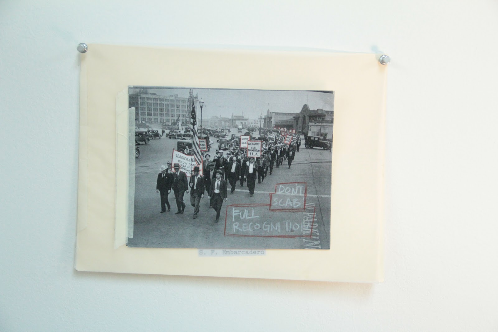
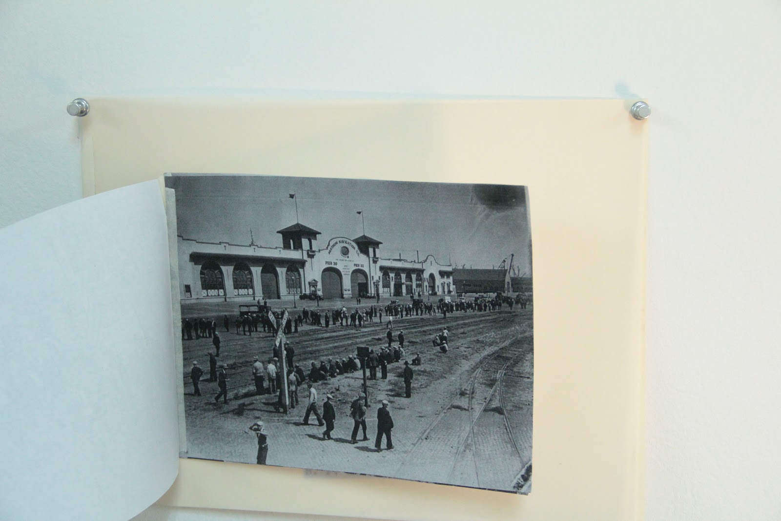
narrow my focus specifically on the taverns, musical nightclubs and deviant lifestyles of the area’s residents from the early 1900’s to modern day. As part of my research I have chosen to gather video footage of the various activities such as drinking, betting and dancing. I have also begun asking local entrepreneurs (such as bar owners) for their opinion on life in both the past and present day Tenderloin. In addition to some original footage, I have also spent significant time finding various outside resources. I have chosen the book San Francisco Tenderloin: true stories of heroes, demons, angels, outcasts and a psychotherapist by Larry Wonderling Ph.D. to read in order to further my knowledge of the Tenderloin. I have also been inspired by the black and white photography series of the Tenderloin by Sean Desmond for its ability to capture the essence of this district. Besides using the internet for basic research and historical information, youtube.com has proven a valuable source of a plethora of video clips from the Tenderloin.
For my final
project, I have the goal of presenting a well-rounded survey of various periods
in the Tenderloin’s vice-ridden history. The film begins with Thomas Edison’s
footage of a Tenderloin bar scene dated to 1899. The film then progresses
through the evolution of entertainment in the Tenderloin in the 1920’s and
1930’s as a place to socialize, gamble and partake in the social communion of
organized dance, such as the Charleston.
The film continues onto the 1940’s through the 1960’s, somewhat
considered as the Golden Age of the Tenderloin.
The Blackhawk nightclub was bringing acts such as Duke Ellington, Billie
Holiday and Nat King Cole to the district to perform. Residents had money to
spend on burlesque performances in the Bordellos and alcohol in the bars due to
the economic boom following WWII. In the ‘60s bands such as The Grateful Dead,
Jefferson Airplane, and Crosby, Stills, Nash and Young were recording albums
and playing shows at Sally Rand’s Music Box (now the Great American Music
Hall). The film then chronicles the Tenderloin’s passage through the 1970s to
present day, which has witnessed the decline of the Tenderloin’s popularity as
an entertainment district. Lastly, I am creating an original musical track that
pays tribute to the lively jazz era found in the Tenderloin in and around the
1950s to compliment the imagery. I have
written the instrumentals and invited young local musicians to assist in the
final score. I am also in the process of writing a lyrical narrative of the
history of the Tenderloin’s livelihood which will verbally describe the imagery
presented. I hope that my final piece
will present a beautiful yet brutally honest portrayal of the once thriving entertainment
scene within San Francisco’s Tenderloin district.
Thursday, March 29, 2012


Thursday, March 1, 2012
Financial District
Financial District
Eva Chidester
 It is almost impossible to move through the financial district without feeling a dramatic shift from the surrounding areas of San Francisco. Reflective towers of glass and stone stretch into the sky; existing as architectural displays of power and wealth. This district is the city's largest concentration of corporate headquarters, law firms, and banks. There is an unmistakable sense of corporate power within half a square mile.
I'm interested in exploring the structures of power and masculinity that alienate the financial district from other areas of the city.
 Using a camera, i plan on deconstructing this space and the people who exist within it.

Eva Chidester

I'm interested in exploring the structures of power and masculinity that alienate the financial district from other areas of the city.


Wednesday, February 29, 2012
Chinatown - Group B - Rhiannon
For my section of the Chinatown project, I am focusing on the destruction and rebuilding of Chinatown after the 1906 earthquake and subsequent fire. Chinatown survived the actual earthquake somewhat well, but was almost entirely consumed by the firebreak explosions set off to save the nearby Financial District. Firefighters ran out of dynamite to level the buildings near Kearny, so when they used black gunpowder instead, the wind carried the flames into the previously spared Chinatown.
After the fire, the official death count never even included the Chinese in San Francisco. It was only estimated much later that 3,000 residents of Chinatown were killed. My project will focus on that inconsistency and the struggle for Chinatown's residents to reclaim their homes and businesses after the fire.
 |
| Chinatown after the fire 1906 |
 |
| Chinese Camp after the fire. Residents were blocked by the National Guard from returning to their homes and businesses as they were looted. They were under order to shoot any residents that tried to sneak back to reclaim their belongings. |
 |
| Rebuilt Chinatown |
Port/Waterfront, Group D, Yixin
Attraction
Yixin Yuan
Through research, I am interested in San Francisco waterfront attraction. People come from all over the world to travel San Francisco. Because San Francisco has great place to visit, that place is waterfront. Water surrounds San Francisco on three sides, but the shoreline between the Golden Gate and Bay bridges gets all the attention. There are many attractions. Very year millions people come to visit SF, I maybe design some product that can help visitor more easy to travel SF.


Port/Waterfront, Group D, Tabitha
Tabitha Taraya
 I
I
Although the Port is integral to the history and identity of San Francisco, the City has grown apart from its waterfront despite expanding towards it. This is mainly due to the Port’s almost singular function as a place of industry within a de-industrializing environment. Having reached its height of maritime activity during World War II, the need for the Port’s facilities have been in decline as bridges had been built, technological innovations made in the shipping industry, in addition to, struggling with competition both neighboring and foreign.
Meanwhile, the Port of San Francisco is expected to contribute to city and state-wide interests without financial assistance from either as a public agency responsible for maintaining its own 7 1/2 miles of shoreline. Interests of which often conflict with the ability to improve the situation from decline. Furthermore, previous attempts to develop and reunite with the City have proven ineffective and resulted in even more set backs. Thus, we have arrived at the current Waterfront Land Use Plan adopted in order re-strategize its use and functions; in hopes to “alter the course of history at the Port.”
For my project I plan to create a kit for navigating through the Port’s past attempts at gentrification towards the future. The kit will be complete with an abridged copy of the current Plan, a sort of old Sanborn map that will layer the past plans of redevelopment, a log book detailing these past plans, along with, a few tools for recording and mapmaking reminiscent in aesthetic to maritime navigational devices.
 |
| Images of old Sanborn Maps |
 |
| Maritime logbook and navigational devices |

Port/Waterfront, Group D, Steven
The Worker
Steven Soundara
For
my project, I plan to investigate the evolution of the port workers’
clothing from the port’s inception to modern day. Work clothes have long
since been an influence in the clothes that everyday people wear, with
many styles having been appropriate from their original context to an
entirely different context. I plan to approach this project with a fine
art sensibility. My piece with have an informational research component
as well as a textile and materiality component in the finished project.


Sunday, February 26, 2012
Port/Waterfront, Group D, Stephanie
Progress: Project Semi-Final
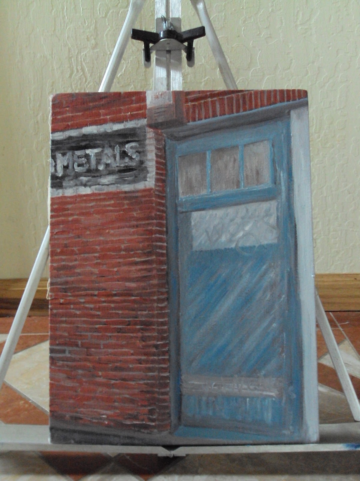
The area that I have decided to focus on has been changing before my very eyes. Recent construction scaffolding on the facade of the building has partially obstructed the doorway which I am focusing my painting on. Therefore, I have decided to work with the circumstances and interpret the gentrification as an adaptive situation. Originally I had planned on leaving the painting in front of the door which I was abstracting -- but now I will place it on the temporary construction cut out door (beige) to the right of the door. The painting will be unframed but hung like a gallery setting on the beige doorway. A photo--similar to this--will be taken as the final representation of my product... a picture within a picture.


 Progress: Painting 02
 Progress: Painting Inspiration
 Progress: Map 02
Illusionary Lines

Building Facade

Building Door
(The painting will hang on the beige temporary door to the right of the actual door.
I will try to get the best possible crop of the area at both a micro and macro scale).
I will try to get the best possible crop of the area at both a micro and macro scale).

Door in Context
(Passersby barely notice or seem to care about the change happening to the area)
(Passersby barely notice or seem to care about the change happening to the area)
Progress: Project Update
For my project I will be delivering 3 items: A) Map B) Painting C) Booklet. The purpose of having three items is to create a composite picture of what the area entails in geographic terms at various scales from macro to micro. The maps is the most comprehensive mean of way-finding for all of the class groups (every single street is represented), the painting provides a personal interpretation of a choice scene (old steel factory door), and the booklet is a smaller and more in depth representation (personal photographs) of first hand images taken from the area during my exploration: most images are about desolation and prevention of access.
The map (40"x40") will be silk screened on a gray/blue paper with a white metallic ink. It can also be used as a catalog cover or exhibition poster. The painting (12"x16") is made with oil colors on white canvas and will ideally be hung in creative way, and the booklet (4"x6") will be displayed next to the painting on a podium as a printed object.


Progress: Map 01

Progress: Painting 01

Progress: Map 00

Progress: Painting 00
Invisible Lines The Port/Waterfront of San Francisco has varied intentions and uses. Mostly advertised as a tourist area, few appreciate or realize its industrial past. The China and India Basins were the crux of commerce and social interaction since the 1860s’ - yet their impact today is marginal as their access is minimal.Through a series of maps, I intend to reveal both the seen and unseen borders within this once-thriving area to help reestablish its presence. A poster series identifies invisible borders within the macro & micro zones of San Francisco. Poster 1: San Francisco | Then & Now, Poster 2: San Francisco | Neighborhoods, Poster 3: San Francisco | Port/Waterfront Uses, Poster 4: San Francisco | India/China Basin Access.  |
| Sketch of poster series proposal |
Why is an
area that once held so much value not being embraced by the San Francisco
community? How is it that an area built on man made resources was responsible
for commerce of the most precious natural resources? When will this area be
ready for change?
Through
graphic cartography I intend to highlight the shifts in usages, stakeholders,
and topographies of the India Basin area to better understand it’s past – and
hopefully where its future could be.

Map of original shoreline (1852) versus modern shoreline (1988)
RISING TIDES
Stephanie Szabo
The San Francisco water line has changed dramatically over the course of its history due to landfill. Whether by natural or man made forces, the perimeter continues to encroach in an ever charged battle over the coastal terrain. Via traditional silk screen print methods, I intend to showcase how these lines are interacting through overlapping layers of ink, what elements are converging over time, and what the future implications might be.

USGS map of where landfill is (original marshes = blue) (waste = pink)

Japanese topographic map of salt flats and seismic hazards
Saturday, February 25, 2012


Subscribe to:
Posts (Atom)